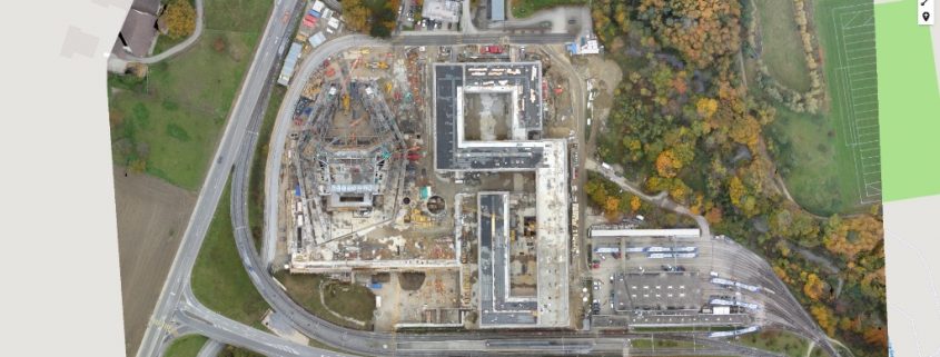
Do you need to map or survey a large property in Marietta, Georgia, monitor construction progress, monitor site security and safety, manage client expectations, or capture great marketing images? Aerial photography services from Building Diagnostics Group may be the ideal solution.
From scouting a site to completing a project, unmanned aerial vehicles (UAVs), also known as drones, enable clients to see conditions they would not be able to see by simply walking the site, including in real-time. Compared to hiring a helicopter or other manned aircraft, drones are more flexible and less expensive.
About Building Diagnostics Group
Building Diagnostics Group (BDG), founded in 2002, is an industry leader in aerial imaging and commercial building thermal inspection services. Our drones have the ability to get into high-risk areas and areas that may be hard to reach with a human crew.
Our fleet of four DJI Inspire and Matrice aircraft are deployed by our FAA Authorized Commercial Drone Remote Pilots based on the specifics of each particular mission. These aircraft are equipped with high-resolution FLIR camera systems and feature a Zenmuse XT 640×512 resolution radiometric infrared camera that is capable of producing high-resolution images and video.
Robert Scherer, President of BDG, is certified in Advanced Building Diagnostics and is an ITC Certified Level III Thermographer with more than 15 years of experience in a wide variety of different applications and 25 years of residential and commercial construction experience in southwest Florida. Robert has presented at building industry conferences and published white papers on specialty applications for the use of infrared thermography.
Applications for Aerial Photography
Aerial photography enables BDG clients to:
- Collect construction site data quickly, safely, and with unparalleled accuracy
- Build, modify and maintain elevated structures, e.g., water tower structures, cell towers and bridges
- Search solar panel fields for issues and monitor power generation
- Detect active roof leaks and water penetration issues without the need for roof access
- Create precision 3D models of your property to view or export
- Track daily progress on job sites
- Access and document hard-to-reach areas
- Make decisions or modifications based on real-time data
- Observe jobsite safety and security in real-time
- Document progress for clients and stakeholders
- Acquire spectacular marketing collateral
- Limit risk and liability with complete documentation
Once BDG’s aerial photography and inspections are completed, we review and analyze the collected data and images and compile an in-depth project report for you along with visual documentation of the property and digital photographs.
Even after your job is complete, BDG will continue to ensure that your results are working for you by making ourselves available for additional project-related consultation, and undertaking additional reporting and investigative work. We enter into relationships with a long-term outlook. Our commitment to you does not end upon delivery.
To discover what Building Diagnostics Group’s aerial photography services can do for your business in Marietta, Georgia, or elsewhere in the nation, please get in touch with us at (888) 317-4568 to discuss the details of your project and receive a quote.

